Soil Erosion and its Control
----------------------------
Erosion
Soil erosion is the detachment and transportation of soil practical from one place to another through the action of wind, water in motion or by the beating action of the rain drops. Mainly water is responsible for soil erosion. As the water ran down the barren slopes, it carries soil with it. One of the principal reasons for low productivity is the progressive deterioration of soil due to erosion. Soil- depth is variable: in some places there is no soil, in some places the soil layer is many meters deep. Top 30 cm of soil supports all human and animal life. This thin layer is largely responsible for both the physical support and nutritional of plant growth. Our existence depends on conserving this vital natural resource.
Causes and ill effects of soil erosion
1. Loss of productive soil
2. Deposition of sand on productive fields
3. Silting of lakes and reservoirs
4. Silting of drainage and irrigation channels.
5. Lowering of water table
6. Fragmentation of land
Erosion classification
Geological erosion – known as natural erosion: It represents erosion under the cover of vegetation. It takes place as a result of the action of water, wind, gravity and glaciers.
It is a very slow process and responsible for soil formation as well as soil loss (means that loss of soil is compensated for by the formation of new soil under natural weathering process). Both together maintain a balance for favorable growth of the plants. As far as its adverse effects on agricultural lands are concerned, geological erosion is not of much consequence.
Accelerated erosion - known as abnormal erosion: When the vegetation is removed and land is put under cultivation, the natural equilibrium between soil building and soil removal is disturbed. The removal of surface soil takes place at much faster rate than it can be built up by the soil forming processes. This is known as accelerated soil erosion or abnormal erosion. It is destructive in nature and caused much land degradation. Only accelerated erosion is matter of concern for the agricultural land and henceforth it will be referred to erosion only.
The erosion can be classified as:
(i) Water erosion,
(ii) Wind erosion, and
(iii) Coastal erosion.
Wind Erosion
It is the removal of soil from the land`s surface by wind in motion. The most serious damage caused by wind erosion is the change in soil texture. The smaller particles of soil are more subjected to movement by wind.
Water Erosion
It is the removal of soil from the land surface by water in motion. Water erosion is due to the dispersive action and transporting power of water. Rainfall is the chief detaching agent in water erosion. Depending upon the degree of erosion and its location, water erosion is further classified as:
(i) Raindrop / splash erosion
(ii) Sheet erosion
(iii) Rill erosion
(iv) Gully erosion
(v) Stream channel erosion
Raindrop or splash erosion
It is the result of direct impact of raindrops on bare soil. If the soil surface is covered with good vegetation, much harmful effects do not occur as the drops break into finer sprays and much of it infiltrates into the ground. It has been observed that, a single rain drop may splash wet soil as much as 60 cm height and move laterally to a distance of 150 cm from the spot.
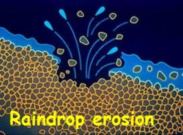
Raindrop ErosionSheet erosion
It is the removal of a fairly uniform layer of soil from the land surface by the action of rainfall and runoff. The top fertile layer of the soil is slowly skimmed off every year and flows down as muddy water. This type of erosion is so slow and extremely harmful to the land. After sometime, the sub-horizon of the soil and finally the bed rock may be exposed rendering the soil unfit for any crop production.
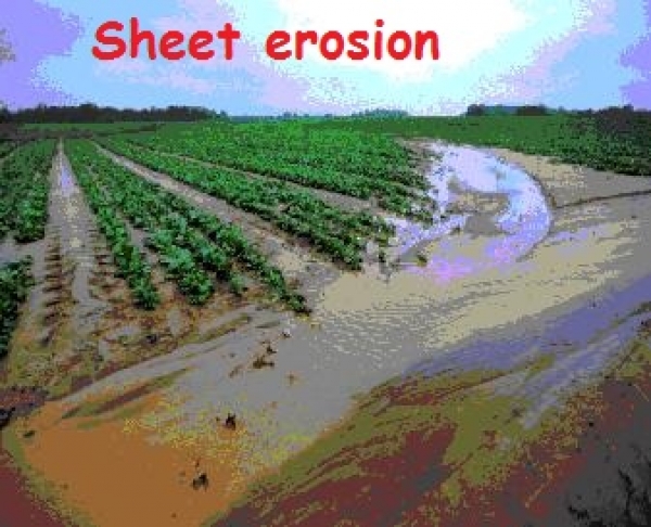
Sheet ErosionRill erosion
Rill erosion is the removal of soil by running water, with the formation of shallow channels that can be smoothed out completely by normal cultivation. Rill erosion is more serious in soils having a loose shallow topsoil. It may be regarded as a transition stage between sheet erosion and gully erosion. Rill erosion is said to have started when channels are large enough to be visible.
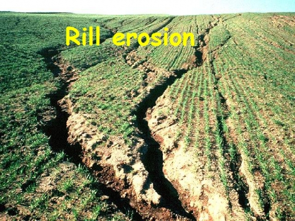
Rill ErosionGully erosion
Gully erosion is the removal of soil by running water, with the formation of channels that cannot be smoothed out completely by normal cultivation. It requires costly structure and practices to control the further advancement of gully. It is an advanced stage of rill erosion.
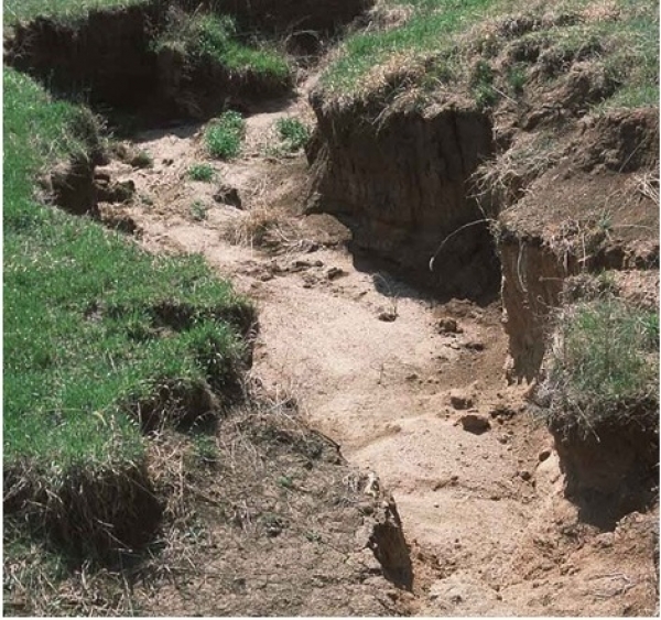
Gully erosionStream Channel erosion
It is the scouring of material from the water channel and the cutting of banks by running water. The flowing water gradually erodes the river bank or undercut below the water surface. This is a very serious problem as the river gets widened every year. The widening of the river destroys huge cultivated lands, villages, cities, rails, bridges, structures etc. Very costly protection measures are required to prevent this type of erosion.
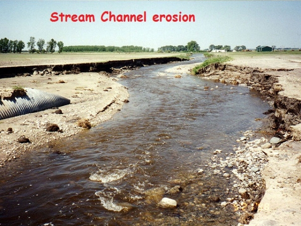
Stream Channel ErosionSoil-Conservation structures
There are three types of soil conservation structures : (i) Temporary structures (ii) Semi permanent structures (iii) Permanent structures
Temporary structures
Terracing
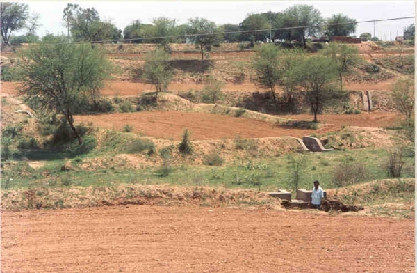
Terracing is a mechanical method by which land surface is modified through construction of ridges, channels and ridges or change of land slope for control soil erosion and conservation of moisture. A terrace reduces the length of the hill-side slope, thereby reducing sheet and rill erosion and prevents formation of gullies.
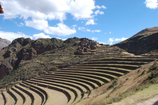
Terraces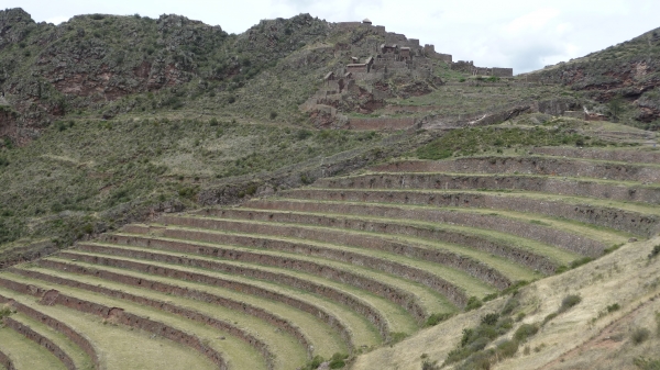
Agricultural Terraces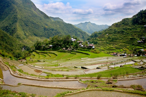
Rice TerracesGraded Bund
In areas of high rainfall (annual rainfall greater than 80 cm) and fine textured soil, the entire runoff cannot easily and economically be stored in the catchment through contour bunding. The excess runoff may not safely be disposed off through surplussing arrangement. Under such situations, graded bunds can be used to dispose off the excess runoff safely. Graded bunds have generally wide and shallow channels and earthen bund laid along a predetermined longitudinal grade. Therefore, contour bunds are mostly used for conservation of moisture in low rainfall areas with permeable soils. Graded bunds are used partly for conservation of moisture and safe disposal of the excess water in high rainfall areas and/or in light soils.
Contour bunding
Bunding or construction of small embankment is carried out to reduce the length of slope, to reduce the velocity of runoff water and to hold the water in the catchment for a longer period. Thus more water infiltrates in to the ground and less runoff and soil erosion takes place. When the bunds are constructed along the contours with some minor deviation to adopt to practical situation, they are known as contour bunds.
Graded BundSemi Permanent Structures
(a) Check dam:-
Temporary check dams are especially adapted to gullies with small watersheds. It conserves soil & water both also reduces soil erosion. The overall height of a temporary check dam should not ordinarily more than 75 cm.
(b) Woven – Wire dams:-
Woven- wire check dams may be used as temporary aids in the establishment of vegetation for permanent control of erosion.
(c) Brush dams:-
Brush dams are the least permanent of all types of check dams, but they are cheap and easy to build. They are best suited far gullies with small drainage areas and soil conditions that permit the driving of necessary anchoring stakes.
(d) Loose rock dam:-
Where stones or rocks of appreciable, they may be used to make semi permanent check dam is gully.
Permanent Structures
Drop slipways
--------------
In drop spillway the water flows through a weir and falls over an apron in which the energy of the water is dissipated. Drop spillways are usually limited to drops of 3 to 4 m. The main components are : (i) Toe wall (ii) Wing wall (iii) Head wall extension (iv) Apron (v) Sidewall (vi) Head wall (vii) Cutoff wall.
Chute spillway
------------
Chute spillways are lined open channels on steep slopes with built in inlet and outlet structures. Flow in Chute spillway is at super- critical velocity. The component parts of Chute spillways are: (i) inlet (ii) vertical curve section (iii) steep channel and (iv) outlet. Chute spillways are frequently used in combination with earth dams to drop water farther than is feasible with drop structures. The Chute spillway usually requires less masonry or Conduit work than do a drop inlet structure of the same capacity and drop.
Drop inlet spillways
--------------------
The drop inlet spillways are ideally suited to conditions where there is need to control the downstream channel flow by providing a temporary storage up stream of the structure. It consists of an earth dam and a pipe spillway. The dam provides the temporary storage of runoff from the contributing water shed while the spillway permits the design discharge to pass downstream. This structures not only used in protection of gullies but also create water storage. The storage water used for “irrigation” and other purpose. It has three components: (i) Inlet (ii) Outlet (iii) Conduit.

Chute Spilway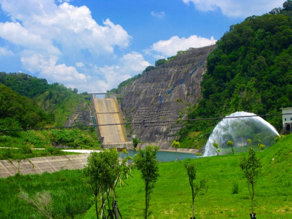
Chute Spilway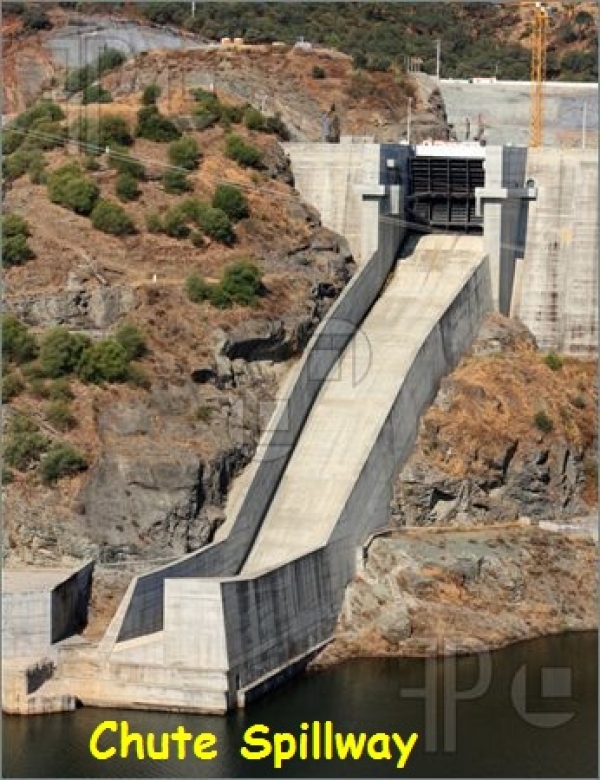
Chute Spilway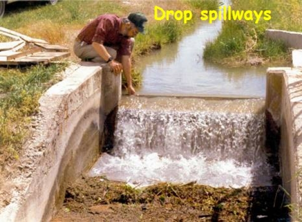
Drop Spillways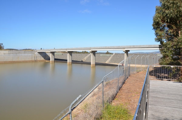
Spillway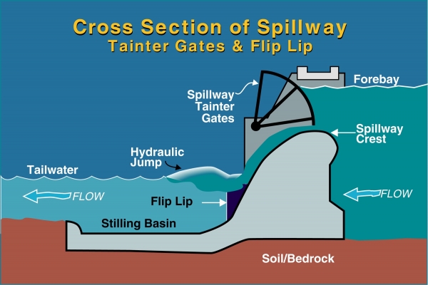
Spillway Cross Section