Precipitation
Generally the terms precipitation and rainfall are used as synonyms with each other. Precipitation can be defined as “earthward falling of water droplets or ice particles that have formed by rapid condensation in the atmosphere and are too large to remain suspended in the atmosphere". In condensation the water droplets is remain suspended in the atmosphere in different forms and it is a first step of precipitation. But in precipitation, those condensed droplets are so big so that they cannot remain in the atmosphere but fall down to the earth surface.
Isohyets are the lines joining the places having equal rainfall or precipitation on the map.
Forms of precipitation
In Liquid form: rain, drizzle, and shower; in Solid form: snow and hail and in Mixed form: sleet and glaze
(A) Rain: - It is defined as precipitation of liquid water particles/ droplets. The size of raindrops is 0.5 mm to 4.0 mm in diameter. The raindrop has a more than 0.5 mm diameter. The droplets are formed due to rapid condensation of moist air mass.
(B) Drizzle: - It is more or less uniform precipitation of very small and minute raindrops. The diameter of drizzle drop is less than 0.5 mm. It falls from low-lying nimbostratus cloud. Fog merges to from drizzle.
(C) Shower: - It is the precipitation lasting for short time with relatively clear intervals. This occurs from passing clouds.
(D) Snow: - Snow is defined as precipitation of white and opaque grains of small or large size ice crystals. It occurs only when the condensation take place below the freezing temperature (0ºC). Snow is generally in the form of individual crystals or in flakes that are aggregate of many crystals. Snowflakes are formed in high clouds. Snow is measured with snow gauge.
(E) Hail: - Hail is a precipitation of small balls or pieces of ice with a diameter ranging from 5 to 50 mm (in solid form). On a warm sunny day, a strong abrupt convection of air mass in freeze zone may cause the formation of pellets having spherical shape and concentric layers of ice. Hail falls from cumulonimbus clouds and is often associated with thunderstorms. Hailstones may achieve even large size as much as cricket ball.
Rainfall associated with the hailstones is called as hailstorm.
(F) Sleet: - Simultaneous precipitation of the mixture of rain and snow is called as sleet.
Mechanism of precipitation formation:
As the rate of condensation is different in different parts of the clouds, the size of the drops is not the same in the clouds. As the air moves about, the large and smaller drops do not follow the same path. The droplets, moving upwards overtake larger ones and thus suffer collision resulting into coalescence or combination. These droplets increase in size and fall down with greater terminal velocity. This is known as collision and coalescence mechanism.
Process of rain formation:
1. First of all water droplets are formed in the atmosphere by the process of condensation.
2. Then these condensed water droplets increase in size by two mechanisms i.e. by collision and by accretion (addition).
Types of precipitation:
All precipitation occurs from clouds. The most important cause of clouds is the adiabatic cooling resulting from the upward movement of air. There are three possible ways in which an air mass may be forced to rise, and each of these produces its own characteristic type of precipitation.
Thus, four are four types of precipitation.
[1] Convectional precipitation
[2] Orographic precipitation.
[3] Cyclonic precipitation
[4] Frontal precipitation
(1) Convectional precipitation
This is largely due to the heating of the earth’s surface, hence the most favorable conditions for its occurrence are always found in the summer months and in the warmer parts of the day. This type of precipitation is of a very short duration and consists of heavy showers.
• Convective precipitation is less effective for crop growth because much of the water is drained off in the form of surface run-off and a little enters the soil.
• However, in the temperature regions it is must effective for plant growth.
• The peculiarity of this precipitation is that it gives maximum rain with minimum cloudiness.
• Clouds involved in this type of precipitation are the cumulo-nimbus or the clouds with great vertical development.
(2) Orographic precipitation
When mountains or highlands acting as barriers to the flow of air. It forces air mass to rise up. The air cools adiabatically form clouds and precipitation may result. The precipitation thus obtained is referred to as orographic (oros = mountain).
• This type of precipitation is commonly found on the windward sides of mountain ranges lying across the path of prevailing winds. After striking the high land, the air is forced to rise and gets cooled. The moisture is condensed and precipitated as rain or snow. On the other side, the amount of precipitation abruptly decreases. Thus on the leeward slopes of these mountains, there always exists a relatively dry area, which is known as rain shadow.
In India the S-W monsoon gives copious (plentiful) rainfall on the windward slope of Western Ghats, where as on the leeward side there are rain shadow areas.
• Another salient feature of orographic precipitation is the “Inversion of rainfall” that means there is a continuous increase in precipitation on the windward slope up to certain height beyond which the amount of precipitation starts diminishing.
• The belt of heaviest precipitation is depending on the latitude, season and exposure. In the Himalayan ranges the maximum condensation takes place at 1200 m height, where as in Alpas it occurs at about 2000 m.
(3) Cyclonic precipitation
Cyclonic precipitation takes place in tropical regions. When currents of air with differing temperature and moisture content meet, the warm and moist air will be forced to rise over the heavier air. Further, when air masses from different directions converge toward a center of low pressure, as is always a case in cyclonic circulation, the air is forced to rise up, as a result cloud formation and precipitation occurs.
In tropical regions, the lifting of warm and moist air mass is almost vertical and is generally accompanied by convection.
(4) Frontal precipitation
Frontal precipitation takes place in temperate regions. In temperate regions, frontal precipitation occurs when the warm and moist air gradually rises above a cold air mass at the front created by contact with the edge of cold air.
• Frontal precipitation along the warm fronts is usually in the form of drizzles.
• It is wide spread and is of a long duration.
• When associated with cold fronts it is always in the form of thundershowers and is of a very short duration.
• Winter precipitation in the north India is a typical example of frontal precipitation. In Europe and North America, most of the winter precipitation is frontal in origin.
Characteristic of Indian monsoon:-
According to Byers, Indian monsoon is the ideal monsoon where differential heating of land and ocean subjected to the annual latitudinal cycle of the sun at its Zenith gives rise to immense seasonal wind regimes. However, the mechanism of Indian monsoon is not as simple as they are thought to be. Although, every school boy understands the Indian monsoon, the India Meteorological Department is still in doubt in regards its origin every year. The trade winds which changed there direction are called monsoon winds. In Arabic, the word monsoon means ‘season; now it is referred to as rainfall.
The Indian monsoon signifies a marked seasonal reversal of wind direction because of its topography. The characteristics of Indian monsoon / monsoonic circulation over India are explained by its topography namely:-
1. Vast size of the Indian sub-continent.
2. Very high and extensive mountain system of Himalayas.
3. The East-West alignment of Himalaya mountain chain which forms a formidable physical barrier between tropical and polar air masses, which is of great meteorological significance.
4. The mightily Himalayas produce hydrodynamic effects that determine the type of precipitation in India.
India experiences two distinct monsoon winds namely: -
1. South-West monsoon winds (summer)
2. North-East monsoon winds (winter)
(1) South–West monsoon: -
During summer (April-May) the intense heating of land results in the formation of low-pressure area in the Northwestern part of the subcontinent. On the contrary, there are high pressure cells formed over the Indian Ocean and Arabian Sea, and there being winter in Australia, a high pressure cell develops over there also. As the pressure over the oceans is high, a sea to land pressure gradient is established during this period. Therefore, the surface airflow is from Sea (high-pressure area) to land (low pressure area).
In India due to peninsula, the S-W monsoon is divided into two branches:
1. Arabian Sea branch (ASB)
2. Bay of Bengal branch (BBB)
The Arabian Sea branch moves northwards and the Bay of Bengal branch moves up to Assam, and then deflected towards northwestwards due to obstruction of Himalayas. Both these branches occasionally close near Delhi.
The Characteristics of South-West monsoon:
• The S-W monsoon period is called grand period of rainfall in India, 75 % of average rainfall of India (1200 mm) is received during the period from June to September.
• The orographic has pronounced influence on the distribution of rainfall during this season.
• For, example the windward side of the Westernghats receives around 2500mm of rainfall while the leeward side receives only 500 mm.
• The amount of rainfall received in NW India is less than that received in NE India.
• Calcutta receives 1190 mm, Patna 1050 mm, Allahabad 760mm and Delhi 560mm of RF during this season.
• Generally the S-W monsoon commences from Kerela normally set on 1st of June every year.
• The monsoon even in the West part is not continuous. There is a break in the monsoon (rainless periods called a dry spell). This phenomenon is closely at the head of Bay of Bengal and their crossing over into the maintained.
• The intensity and frequency of these depressions are responsible for the overall strength or weakness of the monsoon in a given year.
(1) Arabian Sea Branch (ASB): -
The Arabian Sea branch strikes on the elevated western ghats of India at right angles. The windward slopes of Western Ghats receive vary heavy orographic rain. The amount of rainfall on the leeward side goes on diminishing with increasing distance from the sea-coast. At Mahabaleswar the rainfall amounts to 6500 mm, while at Panchgani (only 16km away) the amount of rainfall is reduced to 1700 mm.
A few air currents from ASB are diverted northward to Kutch and Thar deserts. In the advances up to Kashmir, these currents do not bring precipitation in Rajsthan, which remains dry. The Aravali hills being parallel to the direction of these monsoon currents fail to block their passage and lift them. That is why Rajsthan remains a desert.
Some of air currents from ASB manage to proceed towards Chhota Nagpur Plateau through the Narmada and Tapti gaps. These currents ultimately unite with the Bay of Bengal branch.
(2) Bay of Bengal Branch (BBB): -
This branch flows up between Srilanka and Sumatra and Burma. This branch is more powerful than Arabian Sea branch. One branch of BBB strikes Burma and the other Branch moves towards Assam where Cherapunji is situated on the Southern slope of Khasi hills, recording the highest annual average rainfall of 9650 mm in the world. Shillong, hardly 40km away from on the top of Khasi hills receives only about 1400 mm rainfall. Another current of BBB moves westward and advances up the Gangetic plain towards the Punjab. The rainfall occurring in the Gangetic plain is partly controlled by the relief an parts by the cyclonic storms.
• The RF decreases from East to West and from North to South.
• The destination of the ASB and the BBB of monsoon is the low pressure center formed over northwestern region of the subcontinent. However, the direction of winds in Peninsular India is predominantly southwesterly. In the northern plains the air movement is generally from southeast to northeast.
• The southern margin of northern plain is the most frequented track of monsoon of the Bay of Bengal. The cyclonic storms move from east to west along the peninsular hills giving copious rainfall on their southern sides.
2. North-East monsoon (winter monsoon): -
During winter the wind conditions are reversed. In the cold season the entire land mass of Asia becomes the center of very high pressure and the water bodies become low pressure area. The high pressure system develops over Kashmir and the Punjab, controls the prevailing wind direction over the rest of the subcontinent. Contrary to the pressure conditions overland, there are low-pressure centers over the Indian Ocean, the Arabian Sea. In the cold season, therefore there is pressure gradient from land to sea as a result of which winds begin to below from land to sea. These are the North-East or winter monsoons of northern Hemisphere.
The characteristics of North-West monsoon:
• During winter all over the country the wind are light and variable.
• The anticyclonic winds are dry and have no capacity to yield precipitation. Since these winds originated on land and are off-shore, they produce dry and fine weather.
• However, certain areas get winter precipitation. The plains of the Punjab and U.P. are visited by a number of Western disturbances which give moderate to scanty rainfall. The winter precipitation extends up to Patna and disintegrates before they reach Bengal. Higher up in the northern mountainous regions they may be snowfalls.
• The southern part of the Indian peninsula receives rainfall from N-E monsoon currents. These currents while traveling over the Bay of Bengal pick up moisture from ocean surface.
• By the end of September the rainfall starts decreasing in the northern plains of India until it ceases by the month of October. However, in the South India it continues to rain until the middle of December.
• Unlike the sudden burst of monsoon, the retreat of monsoon is gradual. Now the anticyclonic conditions take the place of cyclonic conditions in northern plain.
Monsoon in Gujarat state
The state receives rains under the influence of SW monsoon (June to September). However, the onset and withdrawal of monsoon are not uniform throughout the state.
lMD has divided Gujarat into two subdivisions
1. Gujarat region consisting of North Gujarat, Middle Gujarat and South Gujarat.
2. Saurastra – Kutch region consisting of whole of Kutch and Saurastra regions.
Annual average RF of Gujarat : 820mm
Rainy days : 30 days
Annual average RF of Gujarat Region : 970mm
Rainy days : 43days
Annual average RF of Saurastra-Kutch : 580mm
Rainy days : 23days
Coefficient of variation (CV %) of RF for Gujarat region: 23%,
Saurastra region: 35%
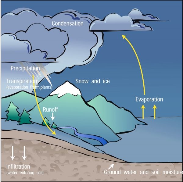
Precipitation & Hydrological Cycle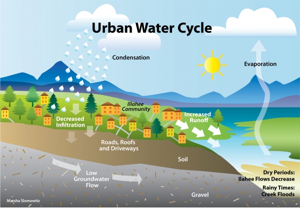
Urban water cycle
Cloud
Drizzle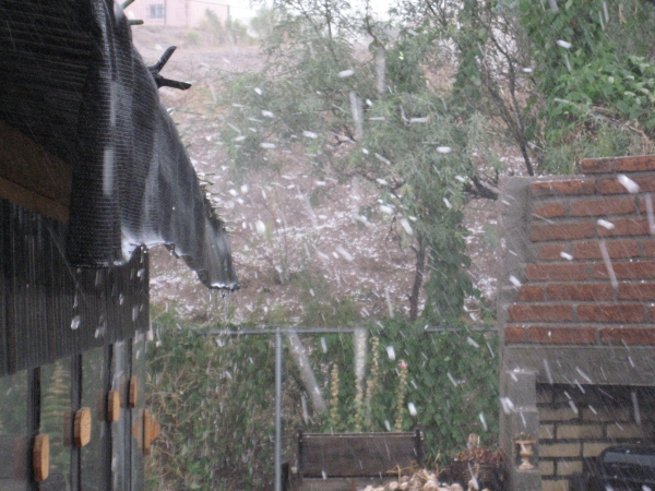
Hail storm